
Our FTC disclosure's magnum opus awaits here. The following article was last updated on Jul 24, 2024 ...
Plot And Ride Your Custom Motorcycle Route Using Voice Guided GPS
Sport touring motorcycle enthusiasts spend a lot of time preparing for extended weekends in twisty paradise. Previous maps are compared, local information is gathered and the forecast, well, let's not even get into that. Two popular topics in today's digital riding world are that of route planning and GPS navigation. Most GPS options (regardless of platform) only allow us to specify a yes/no preference for expressways before deciding which route is most efficient. This soulless, automated travel into the bland is what we in motorbike society are trying to get away from.
“One popular topic in today's digital riding world is that of route planning and GPS navigation. This approach allows for the traversing of custom GPX files.”
For rural county roads, many make use of the anagram-flooded "alphabet soup" technique. Seasoned riders with a disciplined knowledge of the area crease single sheets of typing paper into their tank bag, alpha-numeric road names strewn vertically next to their respective "L" or "R". Having a physical map on hand is advisable for any road trip but for some of us it's hard to focus on the name of the road we just passed.
That's where OsmAnd comes in. This "Linux of the GPS world" navigation app abandons all "wouldn't you rather?" commuting frills for an open-natured culmination of possibilities. At first, OsmAnd feels a little awkward/tricky but after setting aside fifteen to thirty minutes to investigate its configuration, it becomes obvious that this is a great little freebie.
Yeah, that's right. It's free. There's a paid option that we're not exploring. Our goal is to hit the road and follow either our own route or someone else's without the stress of maintaining an internal compass (not that there's anything wrong with that). First, let's have a closer look at the app itself.
OsmAnd is capable of reading GPX files. GPX files are a commonly used XML schema, providing GPS coordinate information for use with host applications. In short, GPX compatible applications can open these files, process their data and display the resulting information on a map. That information can then be used to get from point a to point b (or z) in any which way the file specifies. For those of you who've dealt with poorly compiled GPX data in the past, let us put your mind at ease with this free map plotting service that's not only reliable but easy to use.
How Do I Get My Custom Route Into A GPX File?
This is where the fun begins. Ride With GPS is a map plotting service whose demographic includes bicyclists and scenic travelers. While they do want you to sign up for a premium account, their free account boasts plenty of features including all of that which is necessary to plot and export a custom road map. They're also capable of importing a variety of different map file formats.
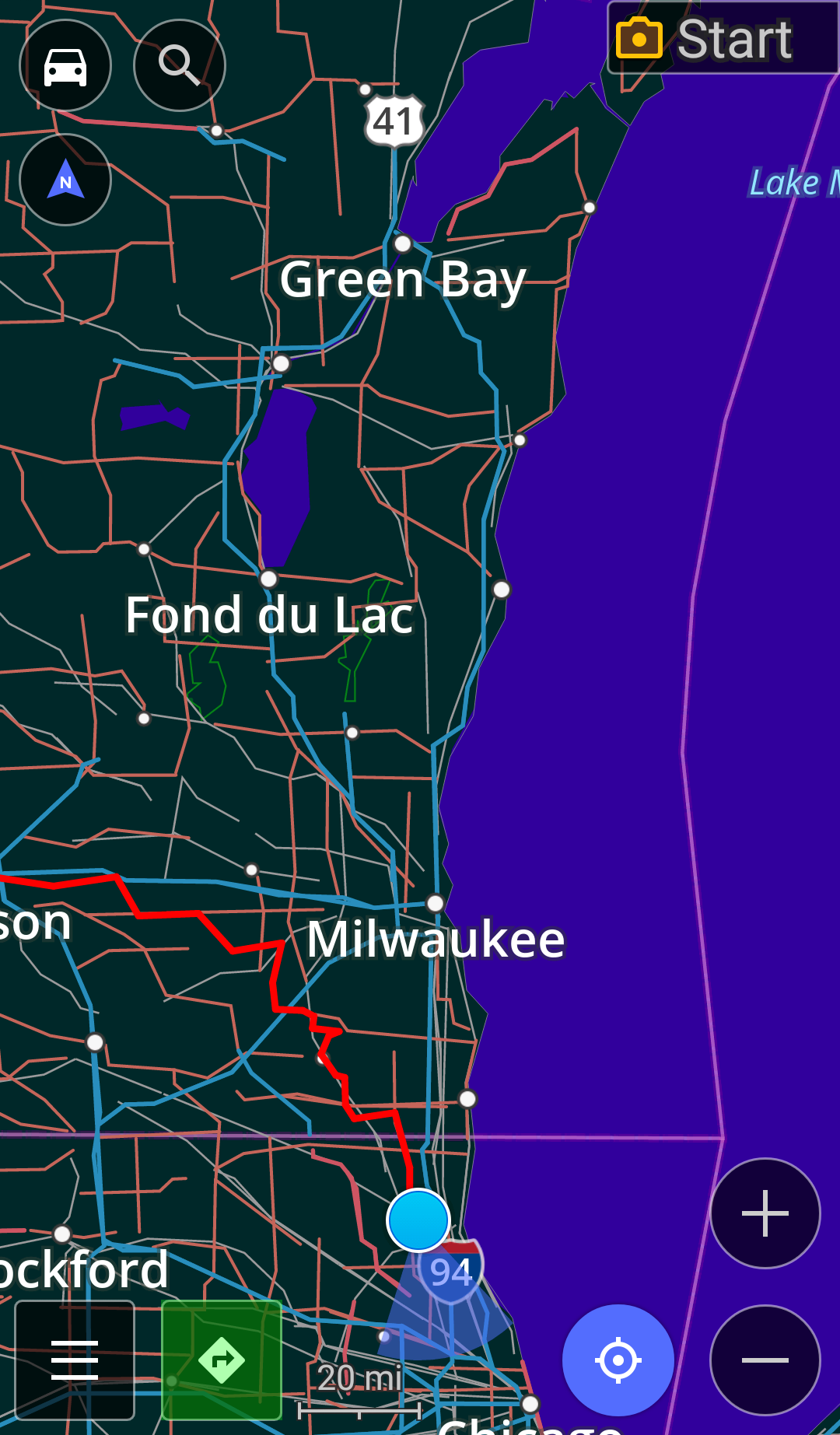
Below is an example route, appropriately dubbed "Cheese Curds and Chicken Strips" by our own Travis Burleson. Clicking the "View full route" link (top-left corner) opens a new window. From there you can select the "Export" tab before downloading its GPX track.
Once activated and logged into their site, plotting a map from scratch is as easy as clicking the "plan" button (top of page). The base maps are currently interfaced with Google which makes for an excellent satellite view. Selecting "follow roads" and clicking on the map for the first time marks the beginning of your route. Optionally, you can enter an address into the "Jump to Location" form before being prompted to make it your starting point. All subsequent entries are met with a "would you like to navigate to this location?" dialogue, allowing you to carefully plan every turn.
Finished working on your map? Clicking the "save" button let's you specify a few more details including description, road conditions and privacy. When all's said and done, you're ready to export the route in (properly compiled) GPX format before importing it into OsmAnd.
Ride With GPS provides excellent support as well, featuring both a user forum and direct contact with representatives. Even their general help pages introduce useful information rather than hypnotizing members through a maze of generic yadas. Also, they invite feature requests.
I've Created And/Or Downloaded My Route's GPX File. What Next?
File management is far more simple with some devices as opposed to others. My current phone (December 12th of 2016) is a somewhat dated Samsung Galaxy S5, which I find convenient for its size, weight and waterproofing. Its file transfer process is tedious at best, requiring third party software and a few extra steps.
If your phone can transfer files via USB, connect it to your computer before locating the GPX file you just downloaded. Browse your phone's file system and navigate to a folder that's easy to find from within your phone's touch screen. Copy your GPX file from your computer to this folder before safely disconnecting your phone. You're all set (skip the next paragraph).
For those of you with a less-than-friendly file transfer process, other software can be simple enough when put to practice. One method is to send the GPX file to your phone using Bluetooth, e-mail or WiFi FTP (advanced). I personally find DropBox to be the easiest solution.
After the transfer is complete, either a file manager such as Explorer or DropBox can locate and open the route on your phone. You'll be prompted to choose which app opens GPX files by default. Select OsmAnd and tap "always."
My GPX File Is Imported Into Osmand. Am I Ready To Ride?
Interacting with technology while riding a motorcycle reads to be both a punchline and a bad Vegas stunt show. The only safe way to do it is to avoid doing so in the first place. Should complicated interaction be unavoidable, pull over before doing what you must. Assuming everything is in order and you're prepared to automate your instructions, you're going to want to hear them. For that, you need a helmet communication interface.
Another important consideration is that of voice quality. TTS (text-to-speech) voice engines have come a long way over the years but one in particular, IVONA TTS HQ, really stands out. Their free Amy UK English voice calms the nerves while alerting you to upcoming navigational maneuvers.
With a helmet interface and TTS voice engine installed, it's time to configure OsmAnd to do its thang. Open OsmAnd, enter its settings screen and carefully think through your personal preferences to situate its behavior. The free version limits the number of offline map downloads, so we advise installing only frequent localities. I've set my own preferences to the following:
General
- Default Profile - Car
- Map Orientation - To Direction of Movement
- Screen Orientation - Same as Device
- Voice Guidance - TTS Voice English
- Voice Guidance Output - Media/Music Audio
- App Theme - Dark (saves battery)
- Use Kalman Filter - Checked
Navigation
- Navigation Service - OsmAnd (Offline)
- Fastest Route - Checked
- Avoid - Toll, Unpaved, Ferries
- Auto-Center Map View - 15 Seconds
- Snap To Road - Checked
- Announce - All But Speed Limit ;-)
One popular concern that's often raised when discussing smartphone GPS navigation is its effect on the subscriber's data plan. If you're worried about your monthly bill, of course it's okay to disable the "use internet" feature. The offline vector maps are sensibly clear and easy to use.
More importantly, your GPS signal has no effect on your statement and short of riding below the tree line of some mountainous region in a third world country, yes you'll have GPS coverage wherever you go. I can't tell you the number of times I've ridden using my phone's GPS navigation where both cell and data signals are rendered null. The GPS technology built into your smartphone is a completely different animal, one which you can trust even in isolated locations.
Everything's Ready. How Do I Traverse My Custom Route Using OsmAnd?

- Activate your device's GPS signal.
- Open the OsmAnd application.
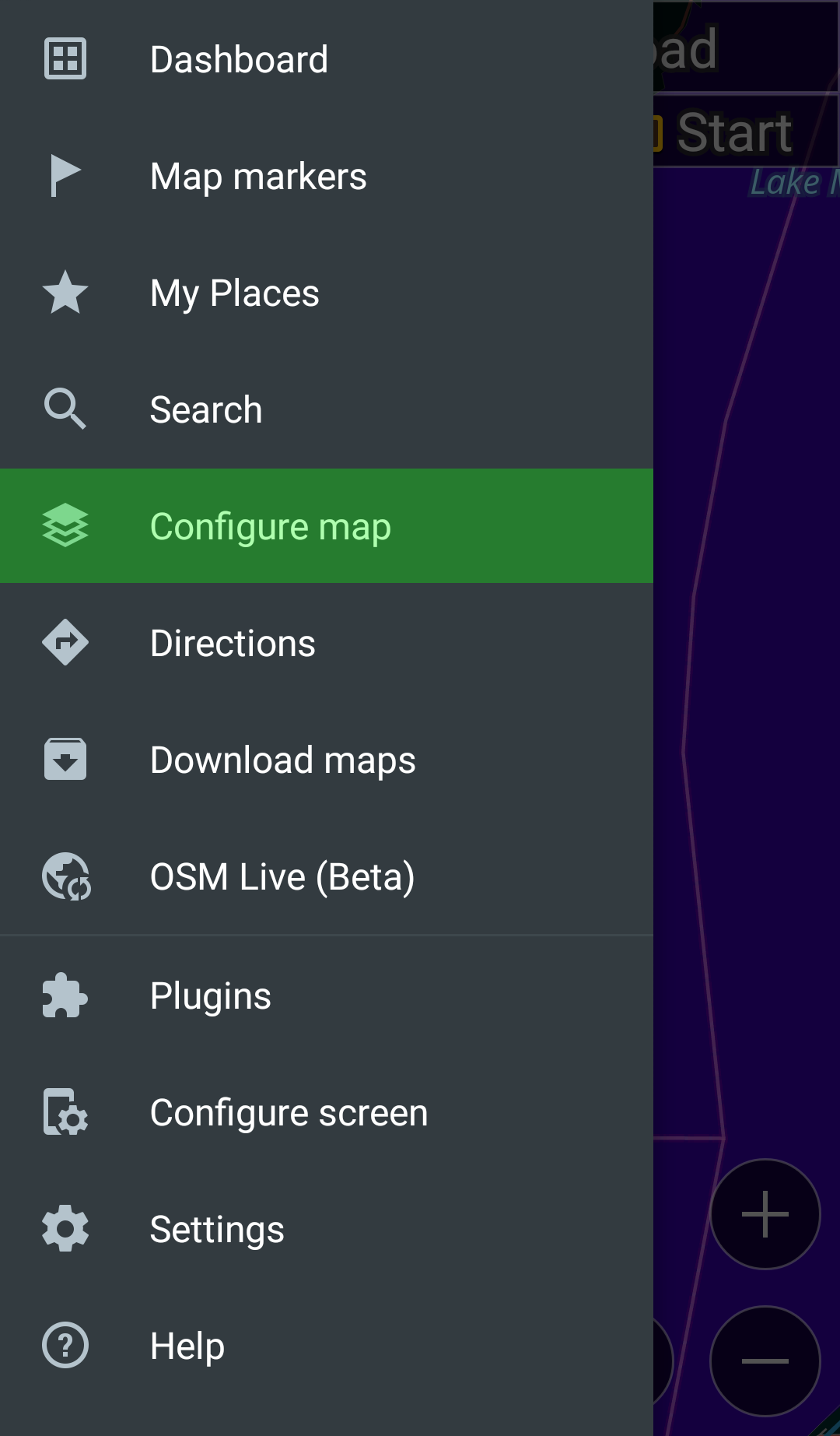
- To the bottom left, tap the menu icon.
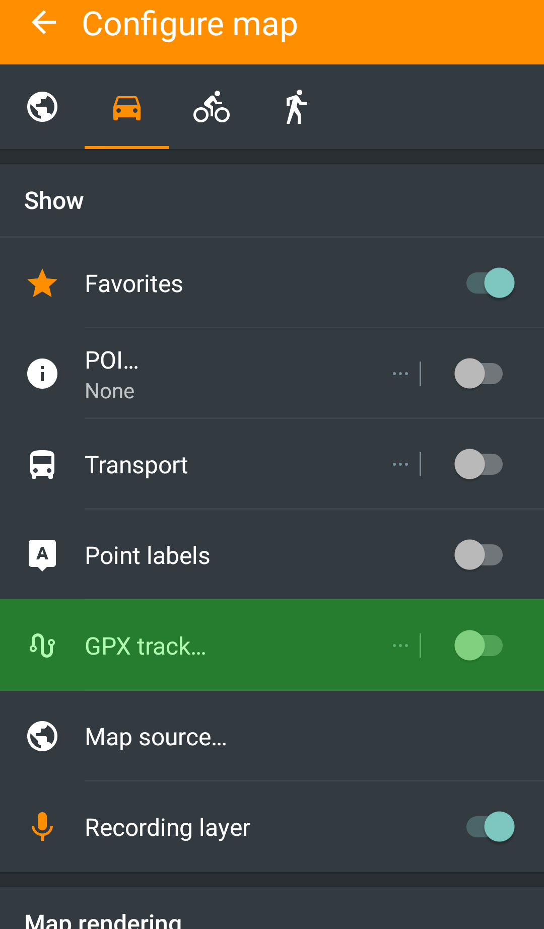
- Toward the top, select "Configure Map".
- Select "GPX Track".
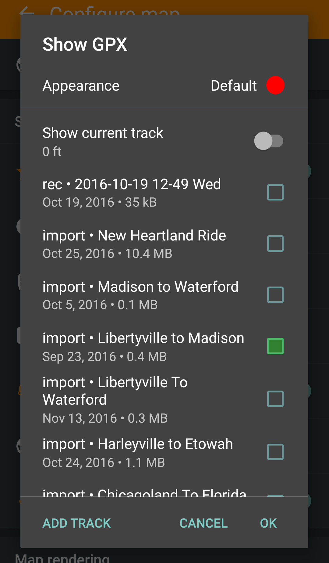
- Select ONE (not multiple) track from your stored listings.
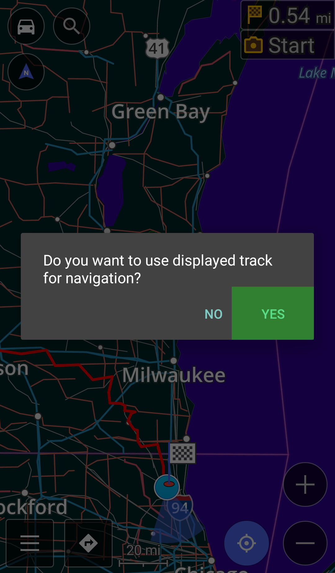
- Next to the menu icon, tap the navigation button (right turn arrow).
- When prompted ("Do you want to use displayed track for navigation?"), select "Yes".
- Toward the bottom right, press the blue navigation icon to begin.
- Enjoy your ride!
Sidenote: To reverse and follow your route back to its initial starting point, select the gear icon and "Reverse GPX Direction" from the navigation menu before initiating step nine. Be careful! The app now thinks it's alright to point you into oncoming traffic! Exit ramps become entrances, one way streets are inverted, dogs and cats living together ... mass hysteria!
A Trio Of Pitfalls Remain
A smartphone GPS signal tends to drain its battery quickly. Long routes (3+ hours) may not be feasible unless you install some form of power port. BurnsMoto sells a variety of different power connectors at reasonable cost. Their weatherproof USB socket is durable and voltage safe, drawing just over one amp. What's more, they're compact and easy to conceal.
Another issue is placement. Loading a custom route into OsmAnd before throwing the phone into your pocket works fine but direct access might be preferable. The ability to (quickly and safely) glance down and confirm you're not lost while also making sure that the application hasn't crashed insures a better journey. For that, there's the Ram Aqua Box. Be sure to measure the dimensions of your phone along with its connected power cable before ordering.
Lastly, I invite anyone using an alternative platform to contribute information for other devices. iPhone, Windows and other PDA users certainly have the same vested interest in the use of said functionality. If it's GPX compatible and ready to better the world of sport touring motorcycles, help us make it known!
What Are Your Favorite Motorcycle Route Planning Resources?
There are other ways to generate and traverse a custom motorcycle route. What method do you prefer? What do you like about it and why? Your input is invited. Leave a comment and/or write an article!
Share Link ...

About Robin Dean
Motorcycle advocate, enthusiast and traveler. Founder, The Riding Obsession (2014). MSF RiderCoach credentials: "loosely regarded adult supervisor, probably good enough for rock 'n' roll" ~ Tidal Playlist


Comments
Robin ...
I'm just posting this quick note to thank you for such a detailed explanation. I plan on using my S5 with OsmAnd to navigate to the GSR Brown County Rally this year. I was able to plot an interesting route on RideWithGPS.com and followed your instructions for getting the file onto my phone before loading it into the app.
This is the first time I'll have used GPS on the bike for a trip and wasn't excited about Google Maps. I'm optimistic that OsmAnd will work well but will have paper backup just in case.
Anyway, I just finished getting the tracks to and from the rally installed and played with getting navigation to work, etc. I'm sitting here thinking: "I'll be damned! I just learned something from Robin F'ing Dean!"
Thanks, buddy. Hope to see you soon.
Greg
That's excellent, Greg!
I'm glad the instructions + process worked out and yeah, physical backups are a wise investment (you taught me that during our first excursion).
Just a heads up:
Go over your maps (on RWPGS) more than once using a zoom level that's both close enough to see intersections and far enough that scrolling through won't take an hour. If there are any "double backs" in your file, OsmAnd will instruct u-turns. That can become annoying (not the app's fault). I remember one such instance where the u-turn became an infinite loop!
I was ride leader for a weekend tour and the three others in tow were beyond confused as to why we were going back and forth along the same one hundred yards. Zooming out in OsmAnd made it very clear what was going on and a quick left put us back on track.
Remember, OsmAnd is reacting to the points you specify, not the track throughout. Once it passes a point, it begins looking for the next nearest point. This too can create a bit of computational static.
If you're riding a route that comes close to shaping a figure-eight without actually intersecting at its center, the points may still come close enough that OsmAnd mistakes the next marker to be closer to the end of your intended route.
One such example is this little beauty.
Looking closely at Burlington, you can see where the track's turn points have a near collision off of Bushnell Road. Because the points in a GPX file aren't ordered numerically, OsmAnd selects the next closest dot and instructs you accordingly. Doh!
In short, OsmAnd works great and is a lot of fun to implement but it's better to babysit its performance (check that it hasn't crashed, etc.) after confirming that your map file is void of double-backs and has enough navigation points at close-call locations to thwart misdirection.
I don't predict you'll run into such looping issues as your journey from Tennessee to Indiana is a relatively straight shot.
Okay! I'm out of ten-dollar words! Happy travels!
p.s. Almost forgot ... should you find yourself stuck in layover mode and be willing to do some writing, we'd love to add your route to the Borg.
Robin,
Just created a new set of tracks to get me back and forth between my place and GSM Motorents in Townsend TN for our upcoming dual-sport adventure. With the help of the local ADV Rider group I've mapped out what looks to be an epic 300+ mile ride to get me there.
Once I have a chance to actually ride these routes I'll be happy to leave some commentary along with the gpx files here for anyone that wants them.
And thanks again for the detailed explanation of how this is done. Its been so long since I created the first routes that I'd forgotten how to do it. But one quick glace back at these instructions and I was on my way.
Printed maps and turn-by-turn instructions will be along for the ride but I'm hoping the Galaxy S5 along with OsmAnd helps keep me on track while keeping my eyes on the road.
Take care and see you soon,
Greg
Glad to, Greg and yes! Please do post a writeup once you get where you're going! Safe travels. 8-)
Great article. I'll offer a different take on connecting the charger straight to the battery. Having it tied straight to the mains allows one to charge devices while parked for the night. This is especially handy when camping without access to power. Between the intercom, camera and phone/gps it's very handy to have things charging via the bike BUT (and I leaned this the hard way) when you're back home, be sure to disconnect it. To this end, having a charger that connects to a battery tender outlet makes this a snap.
Thanks for the very useful article. Do you know if there's a way to modify GPX tracks in OsmAnd? Example: Let's say in the middle of a ride you want to add a waypoint or decide to skip a portion of the trip. On my old TomTom Rider I can mark a waypoint as visited and add waypoints.
Good question, Bob.
You might benefit from exploring this page on the OsmAnd website. While I can't speak to its ease of use, it would appear that it's at least an option. As a sidenote, OsmAnd also allows you to record routes but you have to enable this feature.
Thoughts gone wild? Write an article!